
Sportsmens' Map Co. Houston, Texas Galveston: A. Graham Scott and Emmett R. Ramsey, 1946
- Title: SPORTSMENS' MAP CO. | HOUSTON, TEXAS | GALVESTON
- Author: A. Graham Scott and Emmett R. Ramsey
- Date/Location: 1946, Houston, Texas
- Condition: Age related toning, all else fine
- Inches: 34 x 18-7/8 [Image]
- Centimeters: 86.36 x 47.94 [Image]
- Product ID: 308372
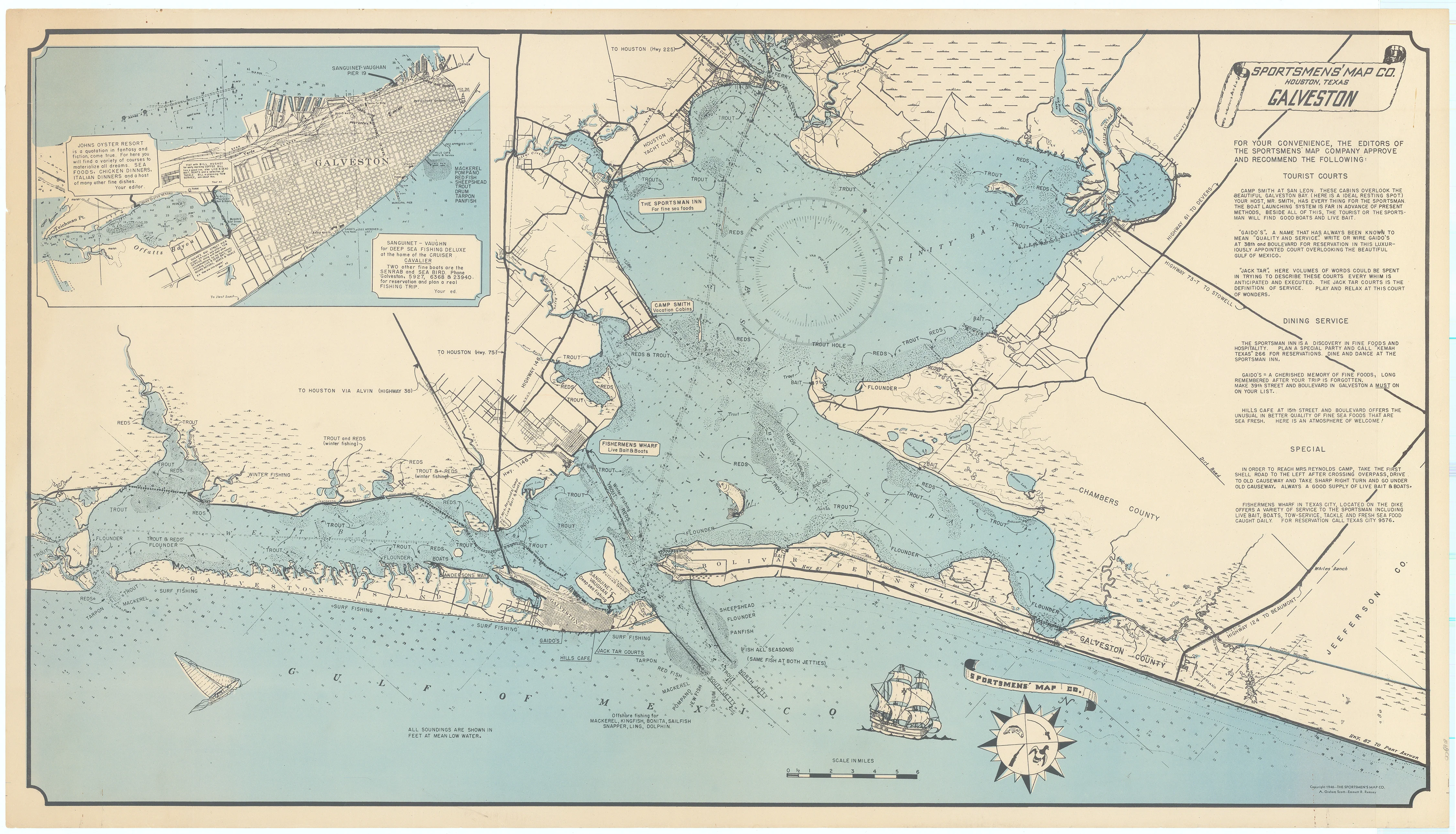
The period following World War II witnessed a dramatic rise in outdoor recreation throughout the United States, fueled largely by the return of tens of thousands of American G.I.s from overseas service. Activities such as fishing, hunting, and camping became immensely popular, prompting the development of new regions specifically designed to accommodate this wave of leisure-seeking tourists.
This 1946 fishing map of Galveston, Texas, published by the Sportsmen’s Map Company of Houston, showcases roughly sixty miles of Gulf of Mexico coastline, as well as the waters of Galveston, Trinity, and East Bays. Anglers could expect to find trout, flounder, and redfish among local catches, while more exotic species such as snapper, sailfish, and bonita were available farther offshore. The upper right corner features recommendations for local restaurants, accommodations, and other points of interest. An inset in the upper left corner offers a detailed view of Galveston city, highlighting several additional dining options.
Description
- Title: SPORTSMENS' MAP CO. | HOUSTON, TEXAS | GALVESTON
- Author: A. Graham Scott and Emmett R. Ramsey
- Date/Location: 1946, Houston, Texas
- Condition: Age related toning, all else fine
- Inches: 34 x 18-7/8 [Image]
- Centimeters: 86.36 x 47.94 [Image]
- Product ID: 308372
The period following World War II witnessed a dramatic rise in outdoor recreation throughout the United States, fueled largely by the return of tens of thousands of American G.I.s from overseas service. Activities such as fishing, hunting, and camping became immensely popular, prompting the development of new regions specifically designed to accommodate this wave of leisure-seeking tourists.
This 1946 fishing map of Galveston, Texas, published by the Sportsmen’s Map Company of Houston, showcases roughly sixty miles of Gulf of Mexico coastline, as well as the waters of Galveston, Trinity, and East Bays. Anglers could expect to find trout, flounder, and redfish among local catches, while more exotic species such as snapper, sailfish, and bonita were available farther offshore. The upper right corner features recommendations for local restaurants, accommodations, and other points of interest. An inset in the upper left corner offers a detailed view of Galveston city, highlighting several additional dining options.


